


maison Chaville Mzudon

ghislainem
User
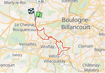

Length
26 km

Max alt
187 m

Uphill gradient
469 m
Km-Effort
32 km

Min alt
89 m

Downhill gradient
464 m
Boucle
No
Creation date :
2024-03-22 07:20:30.499
Updated on :
2024-03-22 13:48:33.315
5h23
Difficulty : Very difficult

FREE GPS app for hiking
 SityTrail
IGN / Geographical institutes
SityTrail Plus
The world is yours!
About
Trail Walking of 26 km to be discovered at Ile-de-France, Yvelines, La Celle-Saint-Cloud. This trail is proposed by ghislainem.
Positioning
Country:
France
Region :
Ile-de-France
Department/Province :
Yvelines
Municipality :
La Celle-Saint-Cloud
Location:
Unknown
Start:(Dec)
Start:(UTM)
437267 ; 5409917 (31U) N.
Comments